
Photographic Data Capture
Photographic Data CAPTURE
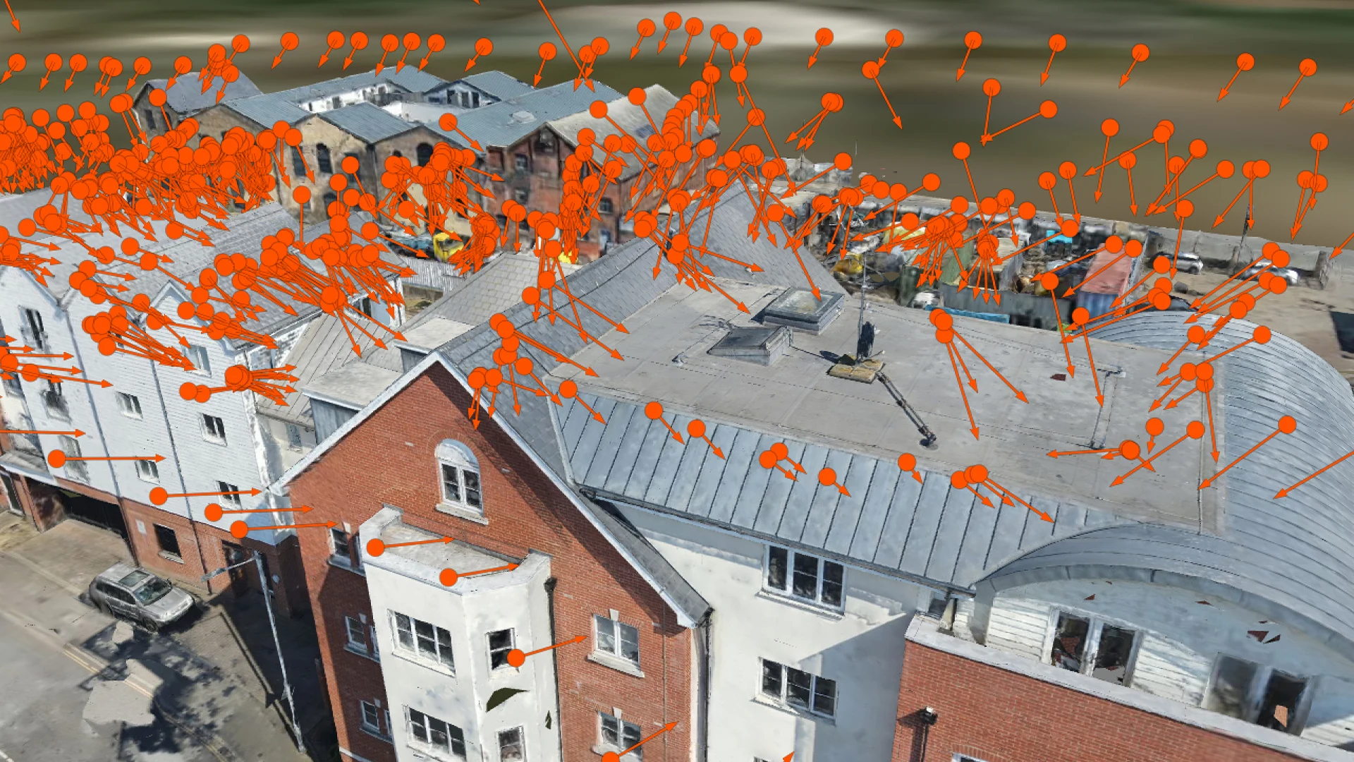
Pre-planned automated drone flights capture hundreds of overlapping, geotagged 4K images of your roof, façade or site, delivered as a searchable image library you can rely on for reports, claims and planning.
DRONE PHOTOGRAPHIC DATA CAPTURE, EXPLAINED
Drone photographic data capture uses pre-planned, automated flight routes to photograph a roof, façade or whole site in a systematic pattern of overlapping, high-resolution images. Every frame is geotagged and time-stamped, so nothing is missed and each shot can be traced back to its exact position in sharp 4K.
Delivered as a clean, searchable image library, it gives surveyors, insurers and property managers dated, defensible evidence for reports, claims and planning. Because the route is repeatable, the same building can be re-flown months or years later and compared like for like, all without ladders or scaffolding.
WHERE PHOTOGRAPHIC DATA MAKES THE DIFFERENCE
Complete site coverage
Overlapping images captured on a planned route cover every roof slope, elevation and detail, so nothing is missed.
Geotagged & time-stamped
Every frame carries its exact position and capture time, so any feature or defect can be located and dated with confidence.
Repeatable re-flights
Automated routes can be flown again months or years later, giving you a like-for-like record of how a building changes over time.
Defensible evidence
Dated, traceable imagery supports surveyors’ reports, insurance claims and planning submissions.
Non-invasive capture
Photograph the whole building from the air with no ladders, no scaffolding and no disruption to occupants.
Sharp 4K detail
High-resolution imagery lets you zoom in on tiles, flashings, cracks and pointing without leaving your desk.
HOW A PHOTOGRAPHIC DATA SURVEY WORKS
-
01
Survey planning
We assess the site, agree what needs to be recorded and plan the flight and airspace so the capture is safe, compliant and focused on what matters to you.
-
02
Automated flight route
A flight route is pre-planned so the drone photographs the whole roof, façade or site in a consistent, overlapping pattern.
-
03
High-resolution capture
The drone flies the route and records hundreds of overlapping 4K images, each one geotagged and time-stamped.
-
04
Quality check & organisation
We review the imagery and organise it by location, so every image can be traced back to its exact position on the building.
-
05
Image library delivered
You receive a clean, searchable image library ready for reports, claims and planning, and the same route can be re-flown whenever you need a comparison.
PHOTOGRAPHIC DATA IN ACTION
A systematic, geotagged image library turns a whole building into a traceable visual record, making features and defects easy to locate, date and communicate to clients, insurers and maintenance teams.
PHOTOGRAPHIC DATA SURVEY FAQs
What is drone photographic data capture?
It is the systematic collection of overlapping, high-resolution aerial images of a roof, façade or site along a pre-planned flight route, with every frame geotagged and time-stamped and delivered as a searchable image library.
What deliverables do I receive?
A clean, searchable library of high-resolution 4K images, organised so every shot can be traced to its exact position. A survey typically produces hundreds of overlapping images, and formats can be tailored for surveyors, insurers or property managers.
How do geotagging and time-stamping help?
Each image records where and when it was taken, so you can locate a feature or defect precisely on the building and show exactly when it was captured. That strengthens reports, claims and planning documents.
Can the same building be re-surveyed and compared?
Yes. Because flight routes are repeatable, we can re-fly the same building months or years later and compare the images like for like to track changes in its condition.
Do I need scaffolding or roof access?
No. The drone captures the whole roof, façade or site from the air, so there are no ladders, no scaffolding and no working at height. That makes a drone survey faster, safer and lower cost.
Which areas do you cover?
We carry out photographic data surveys across London and UK-wide. Get in touch with your location and we will confirm availability.
Book a photographic data survey
Get a complete, geotagged and time-stamped image record of your roof, façade or site, flown safely and delivered as a searchable library
Explore more: 3D Photogrammetry / Property Inspections / Thermal Imaging